|
|
|||||||||||||||||
| Point ID: 99 | Downloads | Plots | Site Data | Code: 05AD021 |
|
|
|||||||||||||||||
| Download | |
|---|---|
| Site Descriptor Information | Site Time Series Data |
| Link to all available data | |
| View: | Time Series | All |
| Units: | mm |
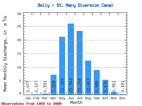
| Statistic | Jan | Feb | Mar | Apr | May | Jun | Jul | Aug | Sep | Oct | Nov | Dec | Annual |
|---|---|---|---|---|---|---|---|---|---|---|---|---|---|
| Mean | 0.08 | 0.13 | 0.39 | 7.23 | 21.16 | 25.94 | 23.26 | 12.41 | 8.99 | 5.48 | 0.95 | 0.18 | 8.16 |
| Standard Deviation | 0.29 | 0.40 | 1.19 | 9.35 | 19.96 | 19.62 | 14.38 | 8.16 | 6.69 | 6.37 | 2.18 | 0.55 | 5.50 |
| Min | 0.00 | 0.00 | 0.00 | 0.00 | 0.00 | 0.00 | 0.58 | 0.00 | 0.00 | 0.00 | 0.00 | 0.00 | 0.77 |
| Max | 1.59 | 1.65 | 7.02 | 27.40 | 62.80 | 64.50 | 53.90 | 31.20 | 21.80 | 23.00 | 9.19 | 2.21 | 20.82 |
| Coefficient of Variation | 3.77 | 3.12 | 3.04 | 1.29 | 0.94 | 0.76 | 0.62 | 0.66 | 0.74 | 1.16 | 2.29 | 3.01 | 0.67 |
 Return to R-Arctic Net Home Page