|
|
|||||||||||||||||
| Point ID: 9737 | Downloads | Plots | Site Data | Code: 05054000 |
|
|
|||||||||||||||||
| Download | |
|---|---|
| Site Descriptor Information | Site Time Series Data |
| Link to all available data | |
| View: | Time Series | All |
| Units: | mm |
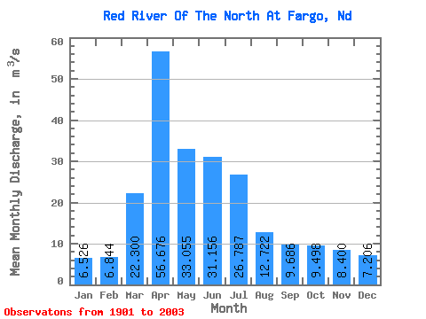
| Statistic | Jan | Feb | Mar | Apr | May | Jun | Jul | Aug | Sep | Oct | Nov | Dec | Annual |
|---|---|---|---|---|---|---|---|---|---|---|---|---|---|
| Mean | 6.53 | 6.84 | 22.30 | 56.68 | 33.05 | 31.16 | 26.79 | 12.72 | 9.69 | 9.50 | 8.40 | 7.21 | 19.25 |
| Standard Deviation | 5.30 | 6.08 | 24.18 | 74.47 | 30.37 | 25.94 | 31.27 | 14.66 | 11.02 | 8.96 | 6.92 | 6.36 | 15.50 |
| Min | 0.00 | 0.01 | 0.76 | 2.89 | 0.23 | 0.08 | 0.00 | 0.00 | 0.00 | 0.00 | 0.00 | 0.00 | 0.45 |
| Max | 20.95 | 38.31 | 133.71 | 507.31 | 151.93 | 145.03 | 161.18 | 93.23 | 64.55 | 49.29 | 26.67 | 35.70 | 76.91 |
| Coefficient of Variation | 0.81 | 0.89 | 1.08 | 1.31 | 0.92 | 0.83 | 1.17 | 1.15 | 1.14 | 0.94 | 0.82 | 0.88 | 0.81 |
 Return to R-Arctic Net Home Page