|
|
|||||||||||||||||
| Point ID: 9732 | Downloads | Plots | Site Data | Code: 05076000 |
|
|
|||||||||||||||||
| Download | |
|---|---|
| Site Descriptor Information | Site Time Series Data |
| Link to all available data | |
| View: | Time Series | All |
| Units: | mm |
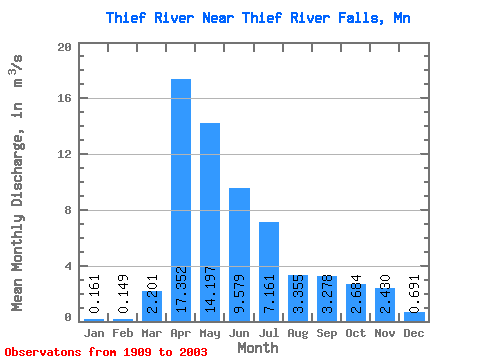
| Statistic | Jan | Feb | Mar | Apr | May | Jun | Jul | Aug | Sep | Oct | Nov | Dec | Annual |
|---|---|---|---|---|---|---|---|---|---|---|---|---|---|
| Mean | 0.16 | 0.15 | 2.20 | 17.35 | 14.20 | 9.58 | 7.16 | 3.35 | 3.28 | 2.68 | 2.43 | 0.69 | 5.46 |
| Standard Deviation | 0.40 | 0.41 | 3.97 | 17.52 | 19.39 | 12.50 | 11.04 | 6.50 | 7.11 | 4.31 | 4.66 | 1.33 | 4.78 |
| Min | 0.00 | 0.00 | 0.00 | 0.22 | 0.05 | 0.00 | 0.00 | 0.00 | 0.00 | 0.00 | 0.00 | 0.00 | 0.04 |
| Max | 2.83 | 2.85 | 21.89 | 80.05 | 121.02 | 63.37 | 59.55 | 31.99 | 45.85 | 18.03 | 28.87 | 6.08 | 21.77 |
| Coefficient of Variation | 2.51 | 2.78 | 1.80 | 1.01 | 1.36 | 1.30 | 1.54 | 1.94 | 2.17 | 1.61 | 1.92 | 1.92 | 0.88 |
 Return to R-Arctic Net Home Page