|
|
|||||||||||||||||
| Point ID: 9729 | Downloads | Plots | Site Data | Code: 05078500 |
|
|
|||||||||||||||||
| Download | |
|---|---|
| Site Descriptor Information | Site Time Series Data |
| Link to all available data | |
| View: | Time Series | All |
| Units: | mm |
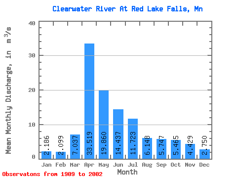
| Statistic | Jan | Feb | Mar | Apr | May | Jun | Jul | Aug | Sep | Oct | Nov | Dec | Annual |
|---|---|---|---|---|---|---|---|---|---|---|---|---|---|
| Mean | 2.19 | 2.10 | 7.04 | 33.52 | 19.86 | 14.44 | 11.72 | 6.15 | 5.75 | 5.46 | 4.43 | 2.75 | 9.60 |
| Standard Deviation | 1.25 | 1.44 | 7.87 | 26.71 | 20.29 | 14.20 | 12.59 | 7.67 | 7.21 | 6.03 | 5.49 | 1.73 | 5.14 |
| Min | 0.60 | 0.54 | 0.38 | 1.73 | 0.91 | 0.75 | 0.24 | 0.04 | 0.08 | 0.28 | 0.54 | 0.61 | 1.95 |
| Max | 6.27 | 10.90 | 32.18 | 99.32 | 143.26 | 86.14 | 67.66 | 47.75 | 45.28 | 38.24 | 34.93 | 9.09 | 24.23 |
| Coefficient of Variation | 0.57 | 0.69 | 1.12 | 0.80 | 1.02 | 0.98 | 1.07 | 1.25 | 1.25 | 1.10 | 1.24 | 0.63 | 0.54 |
 Return to R-Arctic Net Home Page