|
|
|||||||||||||||||
| Point ID: 9707 | Downloads | Plots | Site Data | Code: 05050000 |
|
|
|||||||||||||||||
| Download | |
|---|---|
| Site Descriptor Information | Site Time Series Data |
| Link to all available data | |
| View: | Time Series | All |
| Units: | mm |
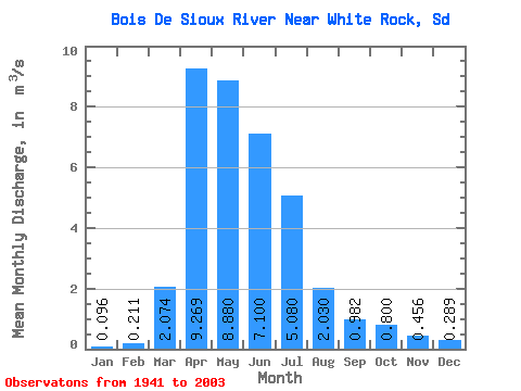
| Statistic | Jan | Feb | Mar | Apr | May | Jun | Jul | Aug | Sep | Oct | Nov | Dec | Annual |
|---|---|---|---|---|---|---|---|---|---|---|---|---|---|
| Mean | 0.10 | 0.21 | 2.07 | 9.27 | 8.88 | 7.10 | 5.08 | 2.03 | 0.98 | 0.80 | 0.46 | 0.29 | 3.12 |
| Standard Deviation | 0.22 | 0.64 | 3.76 | 17.19 | 11.79 | 8.83 | 7.25 | 5.92 | 4.01 | 2.49 | 1.47 | 0.87 | 3.63 |
| Min | 0.00 | 0.00 | 0.00 | 0.00 | 0.01 | 0.00 | 0.00 | 0.00 | 0.00 | 0.00 | 0.00 | 0.00 | 0.01 |
| Max | 1.20 | 4.20 | 17.79 | 108.00 | 40.91 | 31.23 | 29.30 | 33.47 | 30.08 | 15.14 | 8.70 | 5.87 | 15.25 |
| Coefficient of Variation | 2.34 | 3.02 | 1.81 | 1.85 | 1.33 | 1.24 | 1.43 | 2.92 | 4.08 | 3.11 | 3.22 | 3.02 | 1.16 |
 Return to R-Arctic Net Home Page