|
|
|||||||||||||||||
| Point ID: 9695 | Downloads | Plots | Site Data | Code: 05104500 |
|
|
|||||||||||||||||
| Download | |
|---|---|
| Site Descriptor Information | Site Time Series Data |
| Link to all available data | |
| View: | Time Series | All |
| Units: | mm |
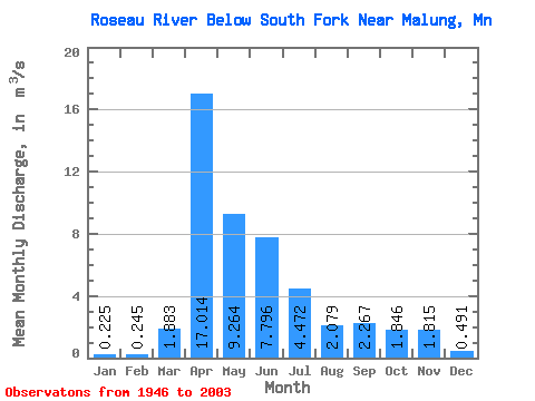
| Statistic | Jan | Feb | Mar | Apr | May | Jun | Jul | Aug | Sep | Oct | Nov | Dec | Annual |
|---|---|---|---|---|---|---|---|---|---|---|---|---|---|
| Mean | 0.23 | 0.24 | 1.88 | 17.01 | 9.26 | 7.80 | 4.47 | 2.08 | 2.27 | 1.85 | 1.81 | 0.49 | 4.17 |
| Standard Deviation | 0.15 | 0.44 | 2.81 | 14.86 | 9.52 | 12.26 | 6.17 | 4.54 | 3.90 | 2.50 | 3.48 | 0.41 | 2.58 |
| Min | 0.00 | 0.00 | 0.02 | 0.16 | 0.25 | 0.12 | 0.00 | 0.00 | 0.00 | 0.00 | 0.01 | 0.00 | 0.20 |
| Max | 0.63 | 2.88 | 14.85 | 57.62 | 45.01 | 78.92 | 32.62 | 25.37 | 20.12 | 9.95 | 24.01 | 1.86 | 9.18 |
| Coefficient of Variation | 0.67 | 1.78 | 1.49 | 0.87 | 1.03 | 1.57 | 1.38 | 2.19 | 1.72 | 1.35 | 1.92 | 0.83 | 0.62 |
 Return to R-Arctic Net Home Page