|
|
|||||||||||||||||
| Point ID: 9689 | Downloads | Plots | Site Data | Code: 05056000 |
|
|
|||||||||||||||||
| Download | |
|---|---|
| Site Descriptor Information | Site Time Series Data |
| Link to all available data | |
| View: | Time Series | All |
| Units: | mm |
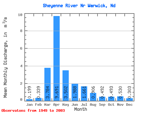
| Statistic | Jan | Feb | Mar | Apr | May | Jun | Jul | Aug | Sep | Oct | Nov | Dec | Annual |
|---|---|---|---|---|---|---|---|---|---|---|---|---|---|
| Mean | 0.20 | 0.34 | 3.78 | 9.69 | 3.50 | 1.99 | 1.66 | 0.91 | 0.49 | 0.49 | 0.53 | 0.30 | 1.99 |
| Standard Deviation | 0.25 | 0.67 | 5.17 | 11.05 | 4.47 | 2.17 | 2.36 | 1.88 | 0.80 | 0.67 | 0.94 | 0.40 | 1.58 |
| Min | 0.01 | 0.02 | 0.04 | 0.45 | 0.29 | 0.05 | 0.01 | 0.00 | 0.02 | 0.03 | 0.04 | 0.02 | 0.16 |
| Max | 1.56 | 4.35 | 22.45 | 50.79 | 24.18 | 9.22 | 12.49 | 11.99 | 4.36 | 3.86 | 6.59 | 2.64 | 6.35 |
| Coefficient of Variation | 1.24 | 1.97 | 1.37 | 1.14 | 1.28 | 1.09 | 1.42 | 2.08 | 1.63 | 1.35 | 1.77 | 1.33 | 0.80 |
 Return to R-Arctic Net Home Page