|
|
|||||||||||||||||
| Point ID: 9683 | Downloads | Plots | Site Data | Code: 05059700 |
|
|
|||||||||||||||||
| Download | |
|---|---|
| Site Descriptor Information | Site Time Series Data |
| Link to all available data | |
| View: | Time Series | All |
| Units: | mm |
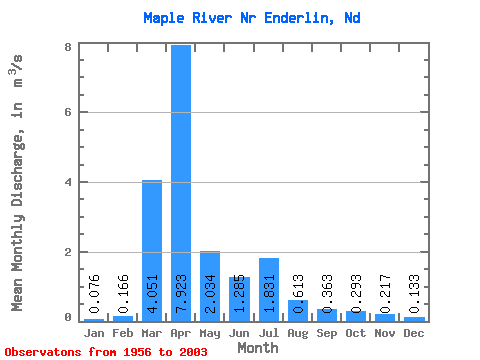
| Statistic | Jan | Feb | Mar | Apr | May | Jun | Jul | Aug | Sep | Oct | Nov | Dec | Annual |
|---|---|---|---|---|---|---|---|---|---|---|---|---|---|
| Mean | 0.08 | 0.17 | 4.05 | 7.92 | 2.03 | 1.28 | 1.83 | 0.61 | 0.36 | 0.29 | 0.22 | 0.13 | 1.61 |
| Standard Deviation | 0.03 | 0.50 | 5.12 | 11.42 | 3.21 | 2.42 | 4.32 | 2.13 | 0.69 | 0.87 | 0.32 | 0.21 | 1.57 |
| Min | 0.03 | 0.04 | 0.06 | 0.06 | 0.06 | 0.04 | 0.04 | 0.04 | 0.04 | 0.04 | 0.04 | 0.04 | 0.06 |
| Max | 0.22 | 3.49 | 17.62 | 61.21 | 18.94 | 12.00 | 24.76 | 14.34 | 3.45 | 5.98 | 1.80 | 1.43 | 6.93 |
| Coefficient of Variation | 0.45 | 3.02 | 1.27 | 1.44 | 1.58 | 1.88 | 2.36 | 3.48 | 1.91 | 2.97 | 1.48 | 1.55 | 0.98 |
 Return to R-Arctic Net Home Page