|
|
|||||||||||||||||
| Point ID: 9679 | Downloads | Plots | Site Data | Code: 05113600 |
|
|
|||||||||||||||||
| Download | |
|---|---|
| Site Descriptor Information | Site Time Series Data |
| Link to all available data | |
| View: | Time Series | All |
| Units: | mm |
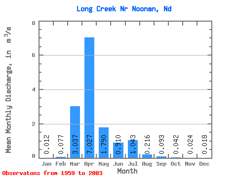
| Statistic | Jan | Feb | Mar | Apr | May | Jun | Jul | Aug | Sep | Oct | Nov | Dec | Annual |
|---|---|---|---|---|---|---|---|---|---|---|---|---|---|
| Mean | 0.01 | 0.08 | 3.04 | 7.03 | 1.79 | 0.91 | 1.04 | 0.22 | 0.09 | 0.04 | 0.02 | 0.02 | 1.20 |
| Standard Deviation | 0.03 | 0.32 | 4.99 | 10.68 | 4.06 | 2.04 | 2.34 | 0.60 | 0.34 | 0.14 | 0.04 | 0.03 | 1.35 |
| Min | 0.00 | 0.00 | 0.00 | 0.00 | 0.00 | 0.00 | 0.00 | 0.00 | 0.00 | 0.00 | 0.00 | 0.00 | 0.00 |
| Max | 0.14 | 2.02 | 16.98 | 39.54 | 20.61 | 10.63 | 12.81 | 3.71 | 2.19 | 0.88 | 0.20 | 0.12 | 5.66 |
| Coefficient of Variation | 2.12 | 4.10 | 1.64 | 1.52 | 2.27 | 2.25 | 2.24 | 2.77 | 3.63 | 3.32 | 1.81 | 1.74 | 1.12 |
 Return to R-Arctic Net Home Page