|
|
|||||||||||||||||
| Point ID: 9675 | Downloads | Plots | Site Data | Code: 05064500 |
|
|
|||||||||||||||||
| Download | |
|---|---|
| Site Descriptor Information | Site Time Series Data |
| Link to all available data | |
| View: | Time Series | All |
| Units: | mm |
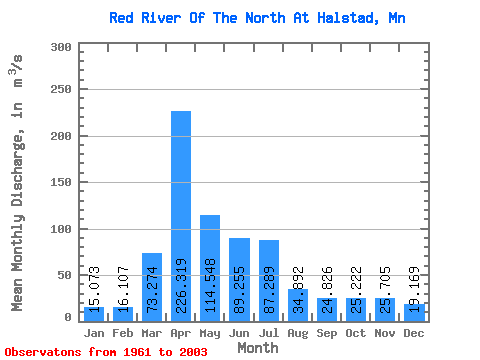
| Statistic | Jan | Feb | Mar | Apr | May | Jun | Jul | Aug | Sep | Oct | Nov | Dec | Annual |
|---|---|---|---|---|---|---|---|---|---|---|---|---|---|
| Mean | 15.07 | 16.11 | 73.27 | 226.32 | 114.55 | 89.25 | 87.29 | 34.89 | 24.83 | 25.22 | 25.70 | 19.17 | 63.54 |
| Standard Deviation | 9.00 | 10.57 | 72.11 | 219.10 | 95.54 | 67.17 | 105.66 | 51.43 | 25.74 | 18.96 | 25.39 | 13.55 | 39.28 |
| Min | 0.91 | 1.30 | 7.06 | 19.95 | 12.71 | 6.84 | 4.34 | 1.69 | 1.09 | 1.74 | 2.62 | 1.45 | 10.23 |
| Max | 35.10 | 55.29 | 267.43 | 1089.07 | 440.91 | 296.70 | 568.12 | 331.21 | 133.23 | 81.41 | 161.59 | 68.33 | 175.42 |
| Coefficient of Variation | 0.60 | 0.66 | 0.98 | 0.97 | 0.83 | 0.75 | 1.21 | 1.47 | 1.04 | 0.75 | 0.99 | 0.71 | 0.62 |
 Return to R-Arctic Net Home Page