|
|
|||||||||||||||||
| Point ID: 9671 | Downloads | Plots | Site Data | Code: 05058500 |
|
|
|||||||||||||||||
| Download | |
|---|---|
| Site Descriptor Information | Site Time Series Data |
| Link to all available data | |
| View: | Time Series | All |
| Units: | mm |
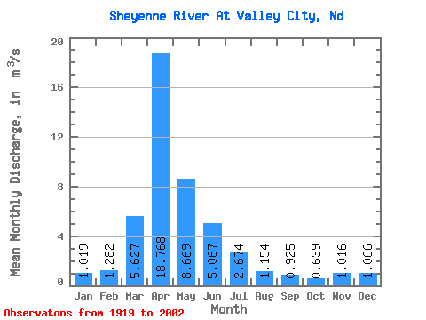
| Statistic | Jan | Feb | Mar | Apr | May | Jun | Jul | Aug | Sep | Oct | Nov | Dec | Annual |
|---|---|---|---|---|---|---|---|---|---|---|---|---|---|
| Mean | 1.02 | 1.28 | 5.63 | 18.77 | 8.67 | 5.07 | 2.67 | 1.15 | 0.93 | 0.64 | 1.02 | 1.07 | 3.47 |
| Standard Deviation | 0.86 | 1.46 | 9.52 | 20.63 | 14.59 | 5.86 | 2.35 | 1.61 | 1.52 | 0.71 | 0.91 | 0.93 | 2.96 |
| Min | 0.00 | 0.00 | 0.00 | 0.09 | 0.28 | 0.24 | 0.01 | 0.00 | 0.00 | 0.00 | 0.00 | 0.00 | 0.52 |
| Max | 3.38 | 5.90 | 50.16 | 84.43 | 84.26 | 34.86 | 7.18 | 8.23 | 8.19 | 3.28 | 3.74 | 4.38 | 15.20 |
| Coefficient of Variation | 0.85 | 1.14 | 1.69 | 1.10 | 1.68 | 1.16 | 0.88 | 1.40 | 1.64 | 1.11 | 0.89 | 0.87 | 0.85 |
 Return to R-Arctic Net Home Page