|
|
|||||||||||||||||
| Point ID: 9658 | Downloads | Plots | Site Data | Code: 05059600 |
|
|
|||||||||||||||||
| Download | |
|---|---|
| Site Descriptor Information | Site Time Series Data |
| Link to all available data | |
| View: | Time Series | All |
| Units: | mm |
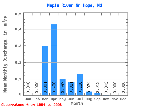
| Statistic | Jan | Feb | Mar | Apr | May | Jun | Jul | Aug | Sep | Oct | Nov | Dec | Annual |
|---|---|---|---|---|---|---|---|---|---|---|---|---|---|
| Mean | 0.00 | 0.00 | 0.30 | 0.43 | 0.10 | 0.08 | 0.13 | 0.02 | 0.01 | 0.00 | 0.00 | 0.00 | 0.08 |
| Standard Deviation | 0.00 | 0.00 | 0.35 | 0.51 | 0.21 | 0.18 | 0.32 | 0.08 | 0.07 | 0.01 | 0.00 | 0.00 | 0.05 |
| Min | 0.00 | 0.00 | 0.00 | 0.00 | 0.00 | 0.00 | 0.00 | 0.00 | 0.00 | 0.00 | 0.00 | 0.00 | 0.00 |
| Max | 0.00 | 0.00 | 1.18 | 1.81 | 1.25 | 0.98 | 1.85 | 0.39 | 0.43 | 0.03 | 0.00 | 0.00 | 0.16 |
| Coefficient of Variation | 4.24 | 1.16 | 1.19 | 2.07 | 2.26 | 2.49 | 3.23 | 5.33 | 4.23 | 4.24 | 0.68 |
 Return to R-Arctic Net Home Page