|
|
|||||||||||||||||
| Point ID: 9657 | Downloads | Plots | Site Data | Code: 05089500 |
|
|
|||||||||||||||||
| Download | |
|---|---|
| Site Descriptor Information | Site Time Series Data |
| Link to all available data | |
| View: | Time Series | All |
| Units: | mm |
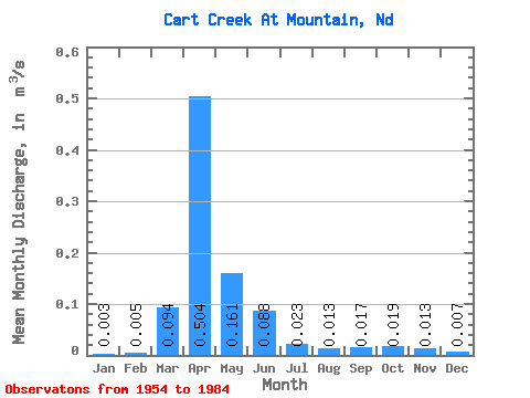
| Statistic | Jan | Feb | Mar | Apr | May | Jun | Jul | Aug | Sep | Oct | Nov | Dec | Annual |
|---|---|---|---|---|---|---|---|---|---|---|---|---|---|
| Mean | 0.00 | 0.01 | 0.09 | 0.50 | 0.16 | 0.09 | 0.02 | 0.01 | 0.02 | 0.02 | 0.01 | 0.01 | 0.08 |
| Standard Deviation | 0.01 | 0.01 | 0.13 | 0.42 | 0.17 | 0.14 | 0.02 | 0.02 | 0.03 | 0.03 | 0.01 | 0.01 | 0.05 |
| Min | 0.00 | 0.00 | 0.00 | 0.03 | 0.01 | 0.00 | 0.00 | 0.00 | 0.00 | 0.00 | 0.00 | 0.00 | 0.01 |
| Max | 0.02 | 0.05 | 0.56 | 1.57 | 0.59 | 0.72 | 0.09 | 0.10 | 0.15 | 0.12 | 0.06 | 0.07 | 0.17 |
| Coefficient of Variation | 1.84 | 2.33 | 1.37 | 0.84 | 1.02 | 1.55 | 1.07 | 1.77 | 1.83 | 1.41 | 0.97 | 1.92 | 0.56 |
 Return to R-Arctic Net Home Page