|
|
|||||||||||||||||
| Point ID: 9656 | Downloads | Plots | Site Data | Code: 05099400 |
|
|
|||||||||||||||||
| Download | |
|---|---|
| Site Descriptor Information | Site Time Series Data |
| Link to all available data | |
| View: | Time Series | All |
| Units: | mm |
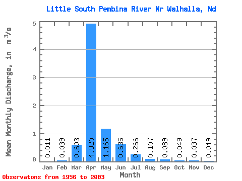
| Statistic | Jan | Feb | Mar | Apr | May | Jun | Jul | Aug | Sep | Oct | Nov | Dec | Annual |
|---|---|---|---|---|---|---|---|---|---|---|---|---|---|
| Mean | 0.01 | 0.04 | 0.60 | 4.92 | 1.17 | 0.64 | 0.27 | 0.11 | 0.09 | 0.05 | 0.04 | 0.02 | 0.62 |
| Standard Deviation | 0.01 | 0.16 | 0.92 | 4.70 | 1.61 | 0.95 | 0.42 | 0.16 | 0.14 | 0.04 | 0.03 | 0.01 | 0.50 |
| Min | 0.00 | 0.00 | 0.00 | 0.14 | 0.07 | 0.01 | 0.01 | 0.00 | 0.00 | 0.01 | 0.01 | 0.00 | 0.04 |
| Max | 0.03 | 0.85 | 3.94 | 13.05 | 7.22 | 4.60 | 1.77 | 0.65 | 0.59 | 0.15 | 0.11 | 0.06 | 1.79 |
| Coefficient of Variation | 0.78 | 4.07 | 1.52 | 0.95 | 1.38 | 1.50 | 1.58 | 1.50 | 1.62 | 0.86 | 0.74 | 0.69 | 0.80 |
 Return to R-Arctic Net Home Page