|
|
|||||||||||||||||
| Point ID: 9648 | Downloads | Plots | Site Data | Code: 05107000 |
|
|
|||||||||||||||||
| Download | |
|---|---|
| Site Descriptor Information | Site Time Series Data |
| Link to all available data | |
| View: | Time Series | All |
| Units: | mm |
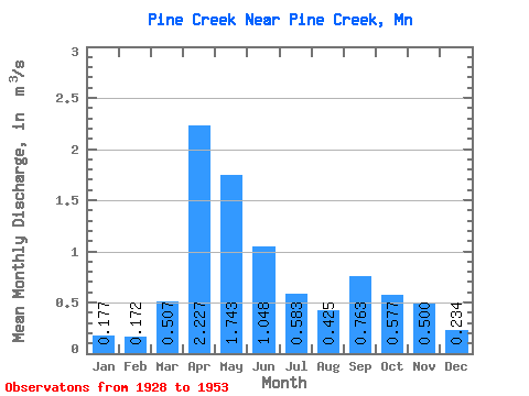
| Statistic | Jan | Feb | Mar | Apr | May | Jun | Jul | Aug | Sep | Oct | Nov | Dec | Annual |
|---|---|---|---|---|---|---|---|---|---|---|---|---|---|
| Mean | 0.18 | 0.17 | 0.51 | 2.23 | 1.74 | 1.05 | 0.58 | 0.42 | 0.76 | 0.58 | 0.50 | 0.23 | 0.76 |
| Standard Deviation | 0.07 | 0.06 | 0.69 | 1.08 | 1.21 | 0.89 | 0.51 | 0.40 | 1.08 | 0.43 | 0.30 | 0.06 | 0.32 |
| Min | 0.03 | 0.06 | 0.06 | 0.53 | 0.50 | 0.40 | 0.13 | 0.03 | 0.11 | 0.17 | 0.17 | 0.10 | 0.27 |
| Max | 0.29 | 0.25 | 3.15 | 4.82 | 6.19 | 3.33 | 1.71 | 1.68 | 4.45 | 1.71 | 1.52 | 0.32 | 1.67 |
| Coefficient of Variation | 0.41 | 0.32 | 1.36 | 0.49 | 0.69 | 0.85 | 0.87 | 0.95 | 1.42 | 0.75 | 0.60 | 0.26 | 0.43 |
 Return to R-Arctic Net Home Page