|
|
|||||||||||||||||
| Point ID: 9638 | Downloads | Plots | Site Data | Code: 05104000 |
|
|
|||||||||||||||||
| Download | |
|---|---|
| Site Descriptor Information | Site Time Series Data |
| Link to all available data | |
| View: | Time Series | All |
| Units: | mm |
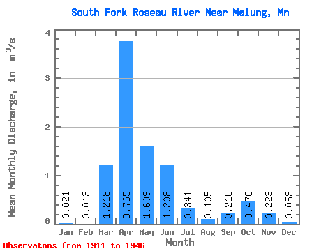
| Statistic | Jan | Feb | Mar | Apr | May | Jun | Jul | Aug | Sep | Oct | Nov | Dec | Annual |
|---|---|---|---|---|---|---|---|---|---|---|---|---|---|
| Mean | 0.02 | 0.01 | 1.22 | 3.77 | 1.61 | 1.21 | 0.34 | 0.10 | 0.22 | 0.48 | 0.22 | 0.05 | 0.73 |
| Standard Deviation | 0.03 | 0.02 | 2.42 | 3.52 | 2.52 | 2.05 | 0.50 | 0.20 | 0.64 | 1.75 | 0.48 | 0.09 | 0.62 |
| Min | 0.00 | 0.00 | 0.00 | 0.32 | 0.00 | 0.00 | 0.00 | 0.00 | 0.00 | 0.00 | 0.00 | 0.00 | 0.03 |
| Max | 0.09 | 0.05 | 7.18 | 13.27 | 9.41 | 6.81 | 1.69 | 0.85 | 2.94 | 8.03 | 1.64 | 0.29 | 2.00 |
| Coefficient of Variation | 1.40 | 1.36 | 1.98 | 0.94 | 1.57 | 1.70 | 1.47 | 1.94 | 2.92 | 3.67 | 2.15 | 1.61 | 0.85 |
 Return to R-Arctic Net Home Page