|
|
|||||||||||||||||
| Point ID: 9630 | Downloads | Plots | Site Data | Code: 05122500 |
|
|
|||||||||||||||||
| Download | |
|---|---|
| Site Descriptor Information | Site Time Series Data |
| Link to all available data | |
| View: | Time Series | All |
| Units: | mm |
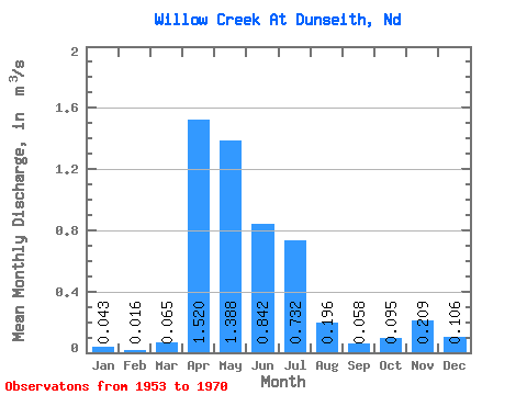
| Statistic | Jan | Feb | Mar | Apr | May | Jun | Jul | Aug | Sep | Oct | Nov | Dec | Annual |
|---|---|---|---|---|---|---|---|---|---|---|---|---|---|
| Mean | 0.04 | 0.02 | 0.07 | 1.52 | 1.39 | 0.84 | 0.73 | 0.20 | 0.06 | 0.10 | 0.21 | 0.11 | 0.43 |
| Standard Deviation | 0.09 | 0.04 | 0.09 | 2.22 | 1.72 | 1.03 | 1.20 | 0.38 | 0.09 | 0.18 | 0.74 | 0.23 | 0.43 |
| Min | 0.00 | 0.00 | 0.00 | 0.02 | 0.02 | 0.00 | 0.00 | 0.00 | 0.00 | 0.00 | 0.00 | 0.00 | 0.01 |
| Max | 0.26 | 0.16 | 0.31 | 6.39 | 4.91 | 3.20 | 4.03 | 1.54 | 0.28 | 0.67 | 3.09 | 0.68 | 1.34 |
| Coefficient of Variation | 2.09 | 2.62 | 1.44 | 1.46 | 1.24 | 1.22 | 1.63 | 1.93 | 1.62 | 1.84 | 3.56 | 2.15 | 1.01 |
 Return to R-Arctic Net Home Page