|
|
|||||||||||||||||
| Point ID: 9623 | Downloads | Plots | Site Data | Code: 05068500 |
|
|
|||||||||||||||||
| Download | |
|---|---|
| Site Descriptor Information | Site Time Series Data |
| Link to all available data | |
| View: | Time Series | All |
| Units: | mm |
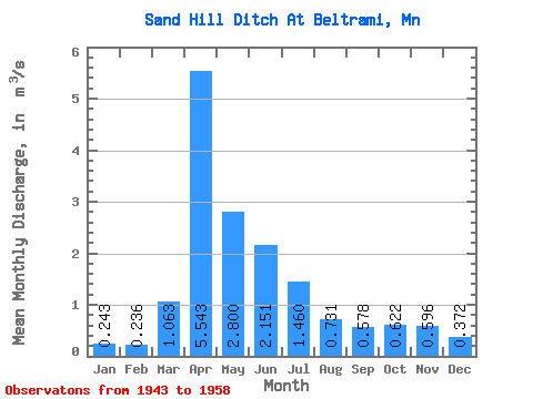
| Statistic | Jan | Feb | Mar | Apr | May | Jun | Jul | Aug | Sep | Oct | Nov | Dec | Annual |
|---|---|---|---|---|---|---|---|---|---|---|---|---|---|
| Mean | 0.24 | 0.24 | 1.06 | 5.54 | 2.80 | 2.15 | 1.46 | 0.73 | 0.58 | 0.62 | 0.60 | 0.37 | 1.13 |
| Standard Deviation | 0.08 | 0.11 | 1.38 | 4.09 | 3.85 | 1.76 | 1.21 | 0.71 | 0.46 | 0.35 | 0.26 | 0.15 | 0.61 |
| Min | 0.14 | 0.02 | 0.00 | 0.78 | 0.66 | 0.58 | 0.40 | 0.25 | 0.24 | 0.27 | 0.24 | 0.14 | 0.62 |
| Max | 0.40 | 0.41 | 4.25 | 13.95 | 16.65 | 6.29 | 5.04 | 3.21 | 1.73 | 1.51 | 1.18 | 0.71 | 2.52 |
| Coefficient of Variation | 0.34 | 0.48 | 1.30 | 0.74 | 1.37 | 0.82 | 0.83 | 0.97 | 0.79 | 0.56 | 0.44 | 0.39 | 0.54 |
 Return to R-Arctic Net Home Page