|
|
|||||||||||||||||
| Point ID: 9616 | Downloads | Plots | Site Data | Code: 05126500 |
|
|
|||||||||||||||||
| Download | |
|---|---|
| Site Descriptor Information | Site Time Series Data |
| Link to all available data | |
| View: | Time Series | All |
| Units: | mm |
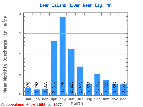
| Statistic | Jan | Feb | Mar | Apr | May | Jun | Jul | Aug | Sep | Oct | Nov | Dec | Annual |
|---|---|---|---|---|---|---|---|---|---|---|---|---|---|
| Mean | 0.38 | 0.29 | 0.34 | 2.61 | 3.77 | 2.23 | 1.41 | 0.53 | 1.04 | 0.76 | 0.56 | 0.54 | 1.13 |
| Standard Deviation | 0.19 | 0.13 | 0.15 | 1.63 | 2.20 | 1.03 | 0.96 | 0.50 | 1.57 | 1.03 | 0.31 | 0.30 | 0.38 |
| Min | 0.00 | 0.00 | 0.09 | 0.31 | 0.95 | 0.85 | 0.23 | 0.07 | 0.01 | 0.02 | 0.01 | 0.00 | 0.57 |
| Max | 0.80 | 0.56 | 0.64 | 5.68 | 8.75 | 3.91 | 3.46 | 1.75 | 5.52 | 3.86 | 1.05 | 1.19 | 1.79 |
| Coefficient of Variation | 0.51 | 0.46 | 0.43 | 0.62 | 0.58 | 0.46 | 0.68 | 0.94 | 1.52 | 1.36 | 0.56 | 0.56 | 0.34 |
 Return to R-Arctic Net Home Page