|
|
|||||||||||||||||
| Point ID: 9605 | Downloads | Plots | Site Data | Code: 05056215 |
|
|
|||||||||||||||||
| Download | |
|---|---|
| Site Descriptor Information | Site Time Series Data |
| Link to all available data | |
| View: | Time Series | All |
| Units: | mm |
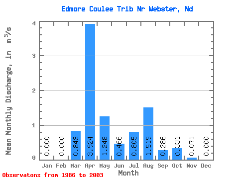
| Statistic | Jan | Feb | Mar | Apr | May | Jun | Jul | Aug | Sep | Oct | Nov | Dec | Annual |
|---|---|---|---|---|---|---|---|---|---|---|---|---|---|
| Mean | 0.00 | 0.00 | 0.84 | 3.92 | 1.25 | 0.47 | 0.81 | 1.52 | 0.29 | 0.33 | 0.07 | 0.00 | |
| Standard Deviation | 1.73 | 4.10 | 2.29 | 0.73 | 1.51 | 5.69 | 0.88 | 0.47 | |||||
| Min | 0.00 | 0.00 | 0.00 | 0.00 | 0.00 | 0.00 | 0.00 | 0.00 | 0.00 | 0.00 | 0.07 | 0.00 | |
| Max | 0.00 | 0.00 | 6.61 | 13.95 | 8.57 | 2.81 | 6.41 | 24.30 | 3.78 | 0.66 | 0.07 | 0.00 | |
| Coefficient of Variation | 2.05 | 1.04 | 1.84 | 1.57 | 1.88 | 3.75 | 3.09 | 1.41 |
 Return to R-Arctic Net Home Page