|
|
|||||||||||||||||
| Point ID: 9604 | Downloads | Plots | Site Data | Code: 05062200 |
|
|
|||||||||||||||||
| Download | |
|---|---|
| Site Descriptor Information | Site Time Series Data |
| Link to all available data | |
| View: | Time Series | All |
| Units: | mm |
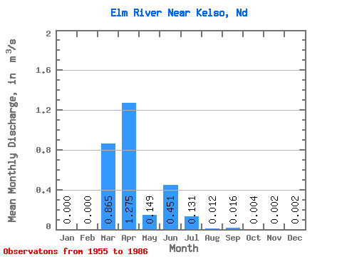
| Statistic | Jan | Feb | Mar | Apr | May | Jun | Jul | Aug | Sep | Oct | Nov | Dec | Annual |
|---|---|---|---|---|---|---|---|---|---|---|---|---|---|
| Mean | 0.00 | 0.00 | 0.86 | 1.27 | 0.15 | 0.45 | 0.13 | 0.01 | 0.02 | 0.00 | 0.00 | 0.00 | 0.08 |
| Standard Deviation | 0.00 | 0.00 | 1.48 | 1.88 | 0.21 | 1.05 | 0.31 | 0.03 | 0.05 | 0.01 | 0.01 | 0.01 | 0.14 |
| Min | 0.00 | 0.00 | 0.00 | 0.00 | 0.00 | 0.00 | 0.00 | 0.00 | 0.00 | 0.00 | 0.00 | 0.00 | 0.00 |
| Max | 0.00 | 0.00 | 4.15 | 6.80 | 0.69 | 3.15 | 1.06 | 0.11 | 0.15 | 0.03 | 0.02 | 0.01 | 0.37 |
| Coefficient of Variation | 3.00 | 3.00 | 1.71 | 1.48 | 1.41 | 2.32 | 2.37 | 2.60 | 3.00 | 2.40 | 3.00 | 3.00 | 1.79 |
 Return to R-Arctic Net Home Page