|
|
|||||||||||||||||
| Point ID: 9581 | Downloads | Plots | Site Data | Code: 05097500 |
|
|
|||||||||||||||||
| Download | |
|---|---|
| Site Descriptor Information | Site Time Series Data |
| Link to all available data | |
| View: | Time Series | All |
| Units: | mm |
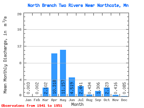
| Statistic | Jan | Feb | Mar | Apr | May | Jun | Jul | Aug | Sep | Oct | Nov | Dec | Annual |
|---|---|---|---|---|---|---|---|---|---|---|---|---|---|
| Mean | 0.00 | 0.00 | 2.10 | 10.32 | 11.16 | 4.52 | 2.44 | 0.43 | 1.31 | 2.12 | 0.42 | 0.09 | 3.16 |
| Standard Deviation | 0.01 | 0.01 | 3.29 | 6.23 | 18.28 | 6.39 | 4.10 | 0.52 | 1.70 | 3.28 | 0.47 | 0.09 | 3.58 |
| Min | 0.00 | 0.00 | 0.00 | 2.02 | 0.52 | 0.04 | 0.04 | 0.00 | 0.00 | 0.00 | 0.01 | 0.00 | 0.89 |
| Max | 0.02 | 0.01 | 8.44 | 18.73 | 58.64 | 20.36 | 11.23 | 1.28 | 5.30 | 9.79 | 1.43 | 0.26 | 9.35 |
| Coefficient of Variation | 2.65 | 2.65 | 1.56 | 0.60 | 1.64 | 1.41 | 1.68 | 1.20 | 1.30 | 1.54 | 1.12 | 1.09 | 1.13 |
 Return to R-Arctic Net Home Page