|
|
|||||||||||||||||
| Point ID: 9580 | Downloads | Plots | Site Data | Code: 05131455 |
|
|
|||||||||||||||||
| Download | |
|---|---|
| Site Descriptor Information | Site Time Series Data |
| Link to all available data | |
| View: | Time Series | All |
| Units: | mm |
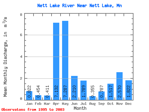
| Statistic | Jan | Feb | Mar | Apr | May | Jun | Jul | Aug | Sep | Oct | Nov | Dec | Annual |
|---|---|---|---|---|---|---|---|---|---|---|---|---|---|
| Mean | 0.82 | 0.45 | 0.41 | 7.13 | 7.29 | 2.21 | 1.79 | 0.35 | 0.79 | 1.52 | 2.57 | 1.82 | 2.36 |
| Standard Deviation | 0.66 | 0.38 | 0.45 | 4.51 | 5.63 | 1.98 | 1.40 | 0.65 | 1.60 | 1.67 | 2.62 | 1.46 | 0.86 |
| Min | 0.04 | 0.00 | 0.00 | 0.02 | 0.02 | 0.34 | 0.04 | 0.00 | 0.00 | 0.01 | 0.00 | 0.04 | 1.46 |
| Max | 1.54 | 1.05 | 1.14 | 13.14 | 14.51 | 5.99 | 4.03 | 1.80 | 4.37 | 4.34 | 5.97 | 3.61 | 3.24 |
| Coefficient of Variation | 0.80 | 0.83 | 1.09 | 0.63 | 0.77 | 0.90 | 0.79 | 1.82 | 2.04 | 1.10 | 1.02 | 0.80 | 0.36 |
 Return to R-Arctic Net Home Page