|
|
|||||||||||||||||
| Point ID: 9577 | Downloads | Plots | Site Data | Code: 05095000 |
|
|
|||||||||||||||||
| Download | |
|---|---|
| Site Descriptor Information | Site Time Series Data |
| Link to all available data | |
| View: | Time Series | All |
| Units: | mm |
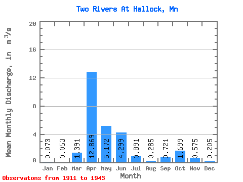
| Statistic | Jan | Feb | Mar | Apr | May | Jun | Jul | Aug | Sep | Oct | Nov | Dec | Annual |
|---|---|---|---|---|---|---|---|---|---|---|---|---|---|
| Mean | 0.07 | 0.05 | 1.39 | 12.87 | 5.17 | 4.30 | 0.89 | 0.28 | 0.72 | 1.70 | 0.57 | 0.20 | 2.41 |
| Standard Deviation | 0.03 | 0.04 | 2.49 | 9.41 | 5.81 | 5.97 | 1.49 | 0.32 | 1.03 | 2.07 | 0.53 | 0.14 | 1.98 |
| Min | 0.01 | 0.00 | 0.01 | 1.29 | 0.61 | 0.47 | 0.21 | 0.03 | 0.02 | 0.12 | 0.17 | 0.07 | 0.75 |
| Max | 0.10 | 0.10 | 6.27 | 28.21 | 15.73 | 18.17 | 4.82 | 1.01 | 3.19 | 5.24 | 1.43 | 0.42 | 4.60 |
| Coefficient of Variation | 0.47 | 0.72 | 1.79 | 0.73 | 1.12 | 1.39 | 1.67 | 1.10 | 1.43 | 1.22 | 0.92 | 0.66 | 0.82 |
 Return to R-Arctic Net Home Page