|
|
|||||||||||||||||
| Point ID: 9567 | Downloads | Plots | Site Data | Code: 05063500 |
|
|
|||||||||||||||||
| Download | |
|---|---|
| Site Descriptor Information | Site Time Series Data |
| Link to all available data | |
| View: | Time Series | All |
| Units: | mm |
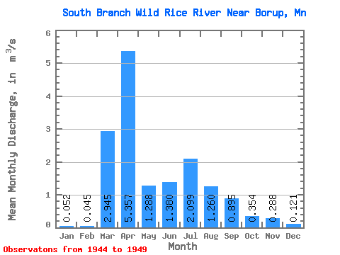
| Statistic | Jan | Feb | Mar | Apr | May | Jun | Jul | Aug | Sep | Oct | Nov | Dec | Annual |
|---|---|---|---|---|---|---|---|---|---|---|---|---|---|
| Mean | 0.05 | 0.04 | 2.94 | 5.36 | 1.29 | 1.38 | 2.10 | 1.26 | 0.90 | 0.35 | 0.29 | 0.12 | 1.12 |
| Standard Deviation | 0.06 | 0.05 | 3.69 | 3.38 | 0.76 | 1.51 | 3.19 | 2.50 | 1.86 | 0.28 | 0.27 | 0.11 | 0.48 |
| Min | 0.01 | 0.00 | 0.00 | 1.43 | 0.42 | 0.20 | 0.09 | 0.03 | 0.01 | 0.04 | 0.05 | 0.02 | 0.49 |
| Max | 0.14 | 0.14 | 7.87 | 10.01 | 2.26 | 3.74 | 8.17 | 6.30 | 4.68 | 0.75 | 0.75 | 0.31 | 1.62 |
| Coefficient of Variation | 1.05 | 1.19 | 1.25 | 0.63 | 0.59 | 1.09 | 1.52 | 1.98 | 2.08 | 0.78 | 0.94 | 0.91 | 0.43 |
 Return to R-Arctic Net Home Page