|
|
|||||||||||||||||
| Point ID: 9559 | Downloads | Plots | Site Data | Code: 05085900 |
|
|
|||||||||||||||||
| Download | |
|---|---|
| Site Descriptor Information | Site Time Series Data |
| Link to all available data | |
| View: | Time Series | All |
| Units: | mm |
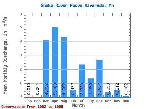
| Statistic | Jan | Feb | Mar | Apr | May | Jun | Jul | Aug | Sep | Oct | Nov | Dec | Annual |
|---|---|---|---|---|---|---|---|---|---|---|---|---|---|
| Mean | 0.01 | 0.00 | 4.09 | 5.01 | 4.30 | 0.50 | 2.33 | 1.35 | 2.67 | 0.35 | 0.51 | 0.08 | 1.53 |
| Standard Deviation | 0.01 | 0.00 | 6.03 | 6.73 | 6.88 | 0.27 | 1.72 | 2.29 | 3.46 | 0.31 | 0.80 | 0.12 | 0.29 |
| Min | 0.00 | 0.00 | 0.00 | 0.76 | 0.12 | 0.14 | 0.07 | 0.00 | 0.00 | 0.00 | 0.00 | 0.00 | 1.28 |
| Max | 0.03 | 0.00 | 12.81 | 15.05 | 14.53 | 0.74 | 3.92 | 4.77 | 7.47 | 0.75 | 1.71 | 0.26 | 1.84 |
| Coefficient of Variation | 1.45 | 1.41 | 1.48 | 1.34 | 1.60 | 0.54 | 0.74 | 1.69 | 1.30 | 0.89 | 1.57 | 1.51 | 0.19 |
 Return to R-Arctic Net Home Page