|
|
|||||||||||||||||
| Point ID: 9522 | Downloads | Plots | Site Data | Code: 15292400 |
|
|
|||||||||||||||||
| Download | |
|---|---|
| Site Descriptor Information | Site Time Series Data |
| Link to all available data | |
| View: | Time Series | All |
| Units: | mm |
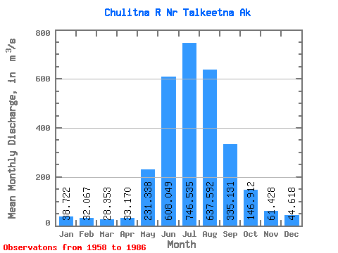
| Statistic | Jan | Feb | Mar | Apr | May | Jun | Jul | Aug | Sep | Oct | Nov | Dec | Annual |
|---|---|---|---|---|---|---|---|---|---|---|---|---|---|
| Mean | 38.72 | 32.07 | 28.35 | 33.17 | 231.34 | 608.05 | 746.53 | 637.59 | 335.13 | 146.91 | 61.43 | 44.62 | 247.41 |
| Standard Deviation | 8.31 | 5.35 | 4.51 | 6.48 | 82.48 | 148.13 | 107.42 | 134.86 | 102.59 | 40.14 | 14.03 | 10.40 | 26.54 |
| Min | 27.59 | 23.22 | 20.91 | 19.82 | 66.68 | 416.63 | 589.63 | 320.11 | 189.83 | 82.06 | 41.91 | 28.32 | 177.45 |
| Max | 57.91 | 42.67 | 36.81 | 45.31 | 393.41 | 1142.11 | 1007.26 | 953.55 | 630.43 | 244.04 | 90.99 | 67.59 | 309.01 |
| Coefficient of Variation | 0.21 | 0.17 | 0.16 | 0.20 | 0.36 | 0.24 | 0.14 | 0.21 | 0.31 | 0.27 | 0.23 | 0.23 | 0.11 |
 Return to R-Arctic Net Home Page