|
|
|||||||||||||||||
| Point ID: 9515 | Downloads | Plots | Site Data | Code: 15284000 |
|
|
|||||||||||||||||
| Download | |
|---|---|
| Site Descriptor Information | Site Time Series Data |
| Link to all available data | |
| View: | Time Series | All |
| Units: | mm |
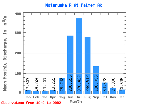
| Statistic | Jan | Feb | Mar | Apr | May | Jun | Jul | Aug | Sep | Oct | Nov | Dec | Annual |
|---|---|---|---|---|---|---|---|---|---|---|---|---|---|
| Mean | 17.61 | 14.72 | 13.41 | 18.25 | 78.74 | 286.62 | 370.43 | 280.61 | 136.04 | 54.62 | 27.89 | 20.64 | 110.09 |
| Standard Deviation | 3.19 | 1.87 | 1.68 | 3.84 | 34.29 | 87.48 | 60.94 | 59.09 | 44.00 | 14.72 | 8.15 | 4.32 | 14.40 |
| Min | 9.87 | 10.78 | 10.19 | 13.17 | 28.52 | 153.34 | 260.69 | 141.36 | 60.11 | 33.03 | 16.09 | 12.46 | 72.44 |
| Max | 23.25 | 17.82 | 16.50 | 27.90 | 170.44 | 488.37 | 530.89 | 445.41 | 253.88 | 87.57 | 50.78 | 29.00 | 138.54 |
| Coefficient of Variation | 0.18 | 0.13 | 0.12 | 0.21 | 0.43 | 0.30 | 0.17 | 0.21 | 0.32 | 0.27 | 0.29 | 0.21 | 0.13 |
 Return to R-Arctic Net Home Page