|
|
|||||||||||||||||
| Point ID: 9481 | Downloads | Plots | Site Data | Code: 15294410 |
|
|
|||||||||||||||||
| Download | |
|---|---|
| Site Descriptor Information | Site Time Series Data |
| Link to all available data | |
| View: | Time Series | All |
| Units: | mm |
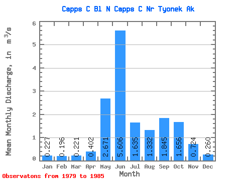
| Statistic | Jan | Feb | Mar | Apr | May | Jun | Jul | Aug | Sep | Oct | Nov | Dec | Annual |
|---|---|---|---|---|---|---|---|---|---|---|---|---|---|
| Mean | 0.23 | 0.20 | 0.22 | 0.40 | 2.67 | 5.61 | 1.64 | 1.33 | 1.84 | 1.66 | 0.72 | 0.26 | 1.39 |
| Standard Deviation | 0.03 | 0.02 | 0.06 | 0.26 | 1.37 | 1.36 | 1.32 | 0.74 | 0.78 | 0.98 | 0.75 | 0.07 | 0.45 |
| Min | 0.17 | 0.17 | 0.16 | 0.17 | 1.42 | 4.29 | 0.76 | 0.47 | 0.90 | 0.91 | 0.26 | 0.18 | 0.94 |
| Max | 0.26 | 0.23 | 0.31 | 0.84 | 5.32 | 8.02 | 4.55 | 2.21 | 3.15 | 3.53 | 2.23 | 0.36 | 2.14 |
| Coefficient of Variation | 0.14 | 0.11 | 0.27 | 0.65 | 0.51 | 0.24 | 0.81 | 0.56 | 0.42 | 0.59 | 1.03 | 0.27 | 0.32 |
 Return to R-Arctic Net Home Page