|
|
|||||||||||||||||
| Point ID: 9469 | Downloads | Plots | Site Data | Code: 15243900 |
|
|
|||||||||||||||||
| Download | |
|---|---|
| Site Descriptor Information | Site Time Series Data |
| Link to all available data | |
| View: | Time Series | All |
| Units: | mm |
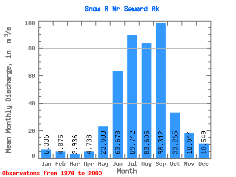
| Statistic | Jan | Feb | Mar | Apr | May | Jun | Jul | Aug | Sep | Oct | Nov | Dec | Annual |
|---|---|---|---|---|---|---|---|---|---|---|---|---|---|
| Mean | 6.34 | 4.88 | 2.94 | 4.74 | 23.08 | 63.68 | 89.74 | 83.61 | 98.31 | 33.27 | 18.04 | 10.55 | 34.19 |
| Standard Deviation | 5.39 | 4.02 | 1.85 | 2.27 | 8.26 | 10.03 | 3.98 | 29.95 | 63.10 | 28.93 | 24.36 | 7.89 | 7.71 |
| Min | 1.61 | 1.19 | 1.11 | 2.31 | 13.91 | 50.40 | 81.15 | 49.96 | 32.75 | 7.91 | 4.62 | 2.47 | 26.62 |
| Max | 14.85 | 12.58 | 6.22 | 7.85 | 40.00 | 76.84 | 92.91 | 158.53 | 216.25 | 70.97 | 67.17 | 20.20 | 43.84 |
| Coefficient of Variation | 0.85 | 0.82 | 0.63 | 0.48 | 0.36 | 0.16 | 0.04 | 0.36 | 0.64 | 0.87 | 1.35 | 0.75 | 0.23 |
 Return to R-Arctic Net Home Page