|
|
|||||||||||||||||
| Point ID: 9460 | Downloads | Plots | Site Data | Code: 15239060 |
|
|
|||||||||||||||||
| Download | |
|---|---|
| Site Descriptor Information | Site Time Series Data |
| Link to all available data | |
| View: | Time Series | All |
| Units: | mm |
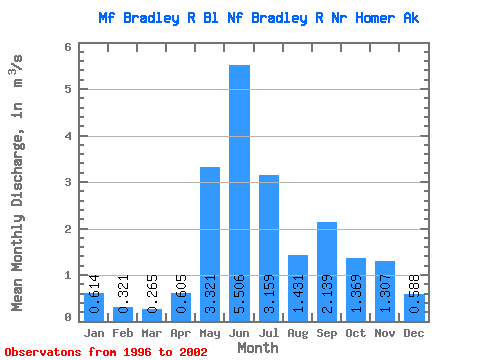
| Statistic | Jan | Feb | Mar | Apr | May | Jun | Jul | Aug | Sep | Oct | Nov | Dec | Annual |
|---|---|---|---|---|---|---|---|---|---|---|---|---|---|
| Mean | 0.61 | 0.32 | 0.27 | 0.60 | 3.32 | 5.51 | 3.16 | 1.43 | 2.14 | 1.37 | 1.31 | 0.59 | 1.80 |
| Standard Deviation | 0.81 | 0.16 | 0.17 | 0.32 | 0.65 | 1.76 | 1.34 | 0.98 | 0.99 | 0.52 | 0.94 | 0.48 | 0.39 |
| Min | 0.08 | 0.06 | 0.08 | 0.27 | 2.75 | 2.93 | 1.29 | 0.35 | 0.78 | 0.66 | 0.46 | 0.22 | 1.45 |
| Max | 2.13 | 0.47 | 0.59 | 1.03 | 4.38 | 7.85 | 5.45 | 3.40 | 3.29 | 2.14 | 2.73 | 1.52 | 2.36 |
| Coefficient of Variation | 1.32 | 0.49 | 0.65 | 0.53 | 0.20 | 0.32 | 0.43 | 0.69 | 0.47 | 0.38 | 0.71 | 0.82 | 0.21 |
 Return to R-Arctic Net Home Page