|
|
|||||||||||||||||
| Point ID: 9458 | Downloads | Plots | Site Data | Code: 15239001 |
|
|
|||||||||||||||||
| Download | |
|---|---|
| Site Descriptor Information | Site Time Series Data |
| Link to all available data | |
| View: | Time Series | All |
| Units: | mm |
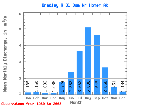
| Statistic | Jan | Feb | Mar | Apr | May | Jun | Jul | Aug | Sep | Oct | Nov | Dec | Annual |
|---|---|---|---|---|---|---|---|---|---|---|---|---|---|
| Mean | 1.14 | 1.15 | 1.09 | 1.08 | 1.77 | 2.38 | 3.66 | 5.10 | 4.65 | 2.66 | 1.45 | 1.18 | 2.22 |
| Standard Deviation | 0.21 | 0.18 | 0.14 | 0.42 | 4.31 | 7.28 | 8.75 | 11.34 | 11.13 | 4.68 | 1.47 | 0.64 | 3.92 |
| Min | 0.68 | 0.68 | 0.68 | 0.58 | 0.02 | 0.01 | 0.04 | 0.60 | 0.89 | 0.32 | 0.64 | 0.68 | 0.77 |
| Max | 1.64 | 1.44 | 1.26 | 2.42 | 16.63 | 27.58 | 33.95 | 44.43 | 43.29 | 16.93 | 6.15 | 3.33 | 15.24 |
| Coefficient of Variation | 0.19 | 0.16 | 0.13 | 0.39 | 2.43 | 3.06 | 2.39 | 2.22 | 2.40 | 1.76 | 1.01 | 0.54 | 1.77 |
 Return to R-Arctic Net Home Page