|
|
|||||||||||||||||
| Point ID: 9425 | Downloads | Plots | Site Data | Code: 15564877 |
|
|
|||||||||||||||||
| Download | |
|---|---|
| Site Descriptor Information | Site Time Series Data |
| Link to all available data | |
| View: | Time Series | All |
| Units: | mm |
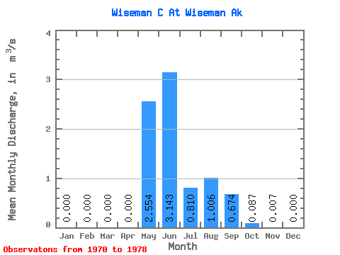
| Statistic | Jan | Feb | Mar | Apr | May | Jun | Jul | Aug | Sep | Oct | Nov | Dec | Annual |
|---|---|---|---|---|---|---|---|---|---|---|---|---|---|
| Mean | 0.00 | 0.00 | 0.00 | 0.00 | 2.55 | 3.14 | 0.81 | 1.01 | 0.67 | 0.09 | 0.01 | 0.00 | 0.72 |
| Standard Deviation | 0.00 | 0.00 | 0.00 | 0.00 | 1.59 | 1.29 | 0.47 | 0.79 | 0.32 | 0.10 | 0.01 | 0.00 | 0.27 |
| Min | 0.00 | 0.00 | 0.00 | 0.00 | 1.01 | 1.47 | 0.21 | 0.27 | 0.29 | 0.00 | 0.00 | 0.00 | 0.41 |
| Max | 0.00 | 0.00 | 0.00 | 0.00 | 5.84 | 5.56 | 1.47 | 2.89 | 1.11 | 0.21 | 0.02 | 0.00 | 1.23 |
| Coefficient of Variation | 0.62 | 0.41 | 0.58 | 0.79 | 0.47 | 1.09 | 1.17 | 0.38 |
 Return to R-Arctic Net Home Page