|
|
|||||||||||||||||
| Point ID: 9400 | Downloads | Plots | Site Data | Code: 15904900 |
|
|
|||||||||||||||||
| Download | |
|---|---|
| Site Descriptor Information | Site Time Series Data |
| Link to all available data | |
| View: | Time Series | All |
| Units: | mm |
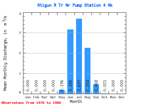
| Statistic | Jan | Feb | Mar | Apr | May | Jun | Jul | Aug | Sep | Oct | Nov | Dec | Annual |
|---|---|---|---|---|---|---|---|---|---|---|---|---|---|
| Mean | 0.00 | 0.00 | 0.00 | 0.00 | 0.20 | 3.17 | 3.70 | 2.25 | 0.47 | 0.02 | 0.00 | 0.00 | 0.81 |
| Standard Deviation | 0.00 | 0.00 | 0.00 | 0.00 | 0.14 | 1.02 | 0.57 | 0.70 | 0.29 | 0.02 | 0.00 | 0.00 | 0.12 |
| Min | 0.00 | 0.00 | 0.00 | 0.00 | 0.01 | 2.16 | 2.65 | 1.29 | 0.13 | 0.00 | 0.00 | 0.00 | 0.59 |
| Max | 0.00 | 0.00 | 0.00 | 0.00 | 0.46 | 5.09 | 4.21 | 3.14 | 0.96 | 0.07 | 0.00 | 0.00 | 0.98 |
| Coefficient of Variation | 0.72 | 0.32 | 0.16 | 0.31 | 0.62 | 1.05 | 0.14 |
 Return to R-Arctic Net Home Page