|
|
|||||||||||||||||
| Point ID: 9379 | Downloads | Plots | Site Data | Code: 15300300 |
|
|
|||||||||||||||||
| Download | |
|---|---|
| Site Descriptor Information | Site Time Series Data |
| Link to all available data | |
| View: | Time Series | All |
| Units: | mm |
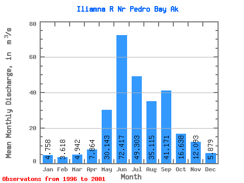
| Statistic | Jan | Feb | Mar | Apr | May | Jun | Jul | Aug | Sep | Oct | Nov | Dec | Annual |
|---|---|---|---|---|---|---|---|---|---|---|---|---|---|
| Mean | 4.76 | 3.62 | 4.94 | 7.86 | 30.14 | 72.42 | 49.30 | 35.12 | 41.17 | 16.64 | 12.09 | 5.88 | 24.41 |
| Standard Deviation | 3.90 | 2.28 | 3.91 | 4.46 | 8.03 | 22.45 | 23.19 | 11.01 | 20.72 | 6.65 | 7.35 | 3.61 | 6.16 |
| Min | 2.13 | 1.75 | 1.72 | 2.49 | 21.31 | 48.58 | 22.33 | 19.60 | 17.75 | 8.19 | 4.57 | 2.39 | 18.14 |
| Max | 11.33 | 7.16 | 11.51 | 14.17 | 41.31 | 107.33 | 83.00 | 46.18 | 61.67 | 24.38 | 21.17 | 11.67 | 32.82 |
| Coefficient of Variation | 0.82 | 0.63 | 0.79 | 0.57 | 0.27 | 0.31 | 0.47 | 0.31 | 0.50 | 0.40 | 0.61 | 0.61 | 0.25 |
 Return to R-Arctic Net Home Page