|
|
|||||||||||||||||
| Point ID: 9335 | Downloads | Plots | Site Data | Code: 15297470 |
|
|
|||||||||||||||||
| Download | |
|---|---|
| Site Descriptor Information | Site Time Series Data |
| Link to all available data | |
| View: | Time Series | All |
| Units: | mm |
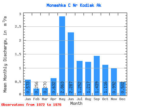
| Statistic | Jan | Feb | Mar | Apr | May | Jun | Jul | Aug | Sep | Oct | Nov | Dec | Annual |
|---|---|---|---|---|---|---|---|---|---|---|---|---|---|
| Mean | 0.57 | 0.26 | 0.27 | 0.63 | 2.86 | 2.29 | 1.25 | 1.22 | 1.44 | 1.12 | 0.99 | 0.50 | 1.09 |
| Standard Deviation | 0.33 | 0.04 | 0.22 | 0.33 | 0.27 | 0.77 | 0.46 | 0.80 | 0.86 | 0.54 | 0.61 | 0.06 | 0.18 |
| Min | 0.37 | 0.21 | 0.05 | 0.34 | 2.58 | 1.24 | 0.73 | 0.40 | 0.54 | 0.38 | 0.21 | 0.44 | 0.88 |
| Max | 1.07 | 0.29 | 0.56 | 0.95 | 3.22 | 3.18 | 1.69 | 2.27 | 2.40 | 1.63 | 1.57 | 0.56 | 1.22 |
| Coefficient of Variation | 0.58 | 0.15 | 0.80 | 0.53 | 0.09 | 0.34 | 0.37 | 0.66 | 0.60 | 0.48 | 0.61 | 0.12 | 0.17 |
 Return to R-Arctic Net Home Page