|
|
|||||||||||||||||
| Point ID: 9333 | Downloads | Plots | Site Data | Code: 15056560 |
|
|
|||||||||||||||||
| Download | |
|---|---|
| Site Descriptor Information | Site Time Series Data |
| Link to all available data | |
| View: | Time Series | All |
| Units: | mm |
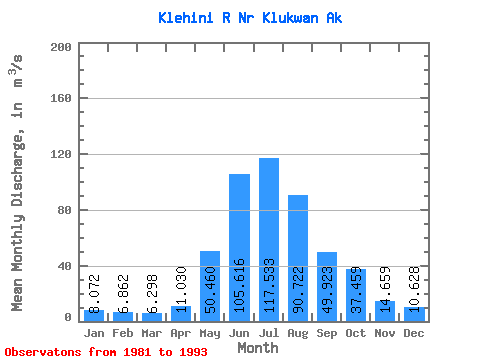
| Statistic | Jan | Feb | Mar | Apr | May | Jun | Jul | Aug | Sep | Oct | Nov | Dec | Annual |
|---|---|---|---|---|---|---|---|---|---|---|---|---|---|
| Mean | 8.07 | 6.86 | 6.30 | 11.03 | 50.46 | 105.62 | 117.53 | 90.72 | 49.92 | 37.46 | 14.66 | 10.63 | 41.84 |
| Standard Deviation | 1.96 | 1.33 | 2.03 | 3.85 | 17.31 | 21.73 | 23.45 | 15.87 | 17.64 | 15.96 | 6.97 | 4.02 | 5.93 |
| Min | 5.14 | 5.58 | 3.76 | 5.74 | 22.29 | 72.24 | 83.01 | 70.56 | 28.01 | 14.89 | 6.49 | 5.75 | 31.19 |
| Max | 11.99 | 10.56 | 11.74 | 20.08 | 80.07 | 137.80 | 153.60 | 118.58 | 77.03 | 60.10 | 30.52 | 18.93 | 50.60 |
| Coefficient of Variation | 0.24 | 0.19 | 0.32 | 0.35 | 0.34 | 0.21 | 0.20 | 0.17 | 0.35 | 0.43 | 0.47 | 0.38 | 0.14 |
 Return to R-Arctic Net Home Page