|
|
|||||||||||||||||
| Point ID: 9317 | Downloads | Plots | Site Data | Code: 15056210 |
|
|
|||||||||||||||||
| Download | |
|---|---|
| Site Descriptor Information | Site Time Series Data |
| Link to all available data | |
| View: | Time Series | All |
| Units: | mm |
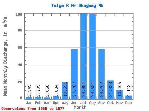
| Statistic | Jan | Feb | Mar | Apr | May | Jun | Jul | Aug | Sep | Oct | Nov | Dec | Annual |
|---|---|---|---|---|---|---|---|---|---|---|---|---|---|
| Mean | 2.35 | 2.71 | 2.07 | 3.63 | 19.59 | 57.79 | 99.98 | 98.62 | 58.20 | 21.83 | 10.41 | 4.11 | 30.91 |
| Standard Deviation | 0.85 | 1.31 | 0.94 | 1.58 | 3.13 | 10.91 | 22.83 | 20.93 | 19.94 | 10.22 | 8.68 | 2.69 | 3.50 |
| Min | 0.94 | 1.40 | 0.78 | 1.52 | 12.79 | 46.02 | 73.40 | 76.98 | 34.40 | 12.57 | 1.46 | 1.54 | 24.13 |
| Max | 3.18 | 5.40 | 3.95 | 6.21 | 23.11 | 74.92 | 129.06 | 135.25 | 88.67 | 43.46 | 22.79 | 9.34 | 33.62 |
| Coefficient of Variation | 0.36 | 0.48 | 0.45 | 0.43 | 0.16 | 0.19 | 0.23 | 0.21 | 0.34 | 0.47 | 0.83 | 0.65 | 0.11 |
 Return to R-Arctic Net Home Page