|
|
|||||||||||||||||
| Point ID: 9242 | Downloads | Plots | Site Data | Code: 15040000 |
|
|
|||||||||||||||||
| Download | |
|---|---|
| Site Descriptor Information | Site Time Series Data |
| Link to all available data | |
| View: | Time Series | All |
| Units: | mm |
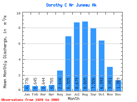
| Statistic | Jan | Feb | Mar | Apr | May | Jun | Jul | Aug | Sep | Oct | Nov | Dec | Annual |
|---|---|---|---|---|---|---|---|---|---|---|---|---|---|
| Mean | 0.78 | 0.65 | 0.64 | 0.76 | 2.61 | 6.92 | 8.68 | 8.80 | 7.93 | 6.39 | 3.05 | 1.39 | 4.04 |
| Standard Deviation | 0.37 | 0.41 | 0.42 | 0.32 | 0.69 | 1.46 | 1.18 | 1.96 | 2.06 | 2.36 | 1.87 | 0.82 | 0.53 |
| Min | 0.28 | 0.28 | 0.29 | 0.37 | 1.47 | 4.25 | 6.83 | 5.60 | 4.03 | 2.76 | 0.90 | 0.40 | 3.11 |
| Max | 1.68 | 2.01 | 2.43 | 1.76 | 3.95 | 9.51 | 11.86 | 13.17 | 12.24 | 12.88 | 10.04 | 3.20 | 5.41 |
| Coefficient of Variation | 0.48 | 0.64 | 0.65 | 0.43 | 0.26 | 0.21 | 0.14 | 0.22 | 0.26 | 0.37 | 0.61 | 0.59 | 0.13 |
 Return to R-Arctic Net Home Page