|
|
|||||||||||||||||
| Point ID: 9223 | Downloads | Plots | Site Data | Code: 15225998 |
|
|
|||||||||||||||||
| Download | |
|---|---|
| Site Descriptor Information | Site Time Series Data |
| Link to all available data | |
| View: | Time Series | All |
| Units: | mm |
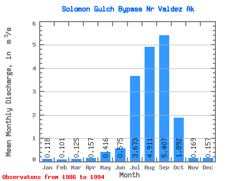
| Statistic | Jan | Feb | Mar | Apr | May | Jun | Jul | Aug | Sep | Oct | Nov | Dec | Annual |
|---|---|---|---|---|---|---|---|---|---|---|---|---|---|
| Mean | 0.12 | 0.10 | 0.12 | 0.16 | 0.42 | 0.57 | 3.67 | 4.91 | 5.41 | 1.89 | 0.17 | 0.16 | 1.57 |
| Standard Deviation | 0.11 | 0.07 | 0.14 | 0.07 | 0.15 | 0.66 | 2.43 | 2.20 | 3.36 | 1.76 | 0.08 | 0.10 | 0.55 |
| Min | 0.00 | 0.00 | 0.00 | 0.03 | 0.22 | 0.12 | 0.09 | 2.80 | 1.03 | 0.09 | 0.06 | 0.04 | 0.80 |
| Max | 0.28 | 0.20 | 0.43 | 0.25 | 0.72 | 2.02 | 6.32 | 8.37 | 9.54 | 5.20 | 0.34 | 0.28 | 2.15 |
| Coefficient of Variation | 0.90 | 0.73 | 1.10 | 0.42 | 0.36 | 1.14 | 0.66 | 0.45 | 0.62 | 0.93 | 0.50 | 0.63 | 0.35 |
 Return to R-Arctic Net Home Page