|
|
|||||||||||||||||
| Point ID: 92 | Downloads | Plots | Site Data | Code: 05AD013 |
|
|
|||||||||||||||||
| Download | |
|---|---|
| Site Descriptor Information | Site Time Series Data |
| Link to all available data | |
| View: | Time Series | All |
| Units: | mm |
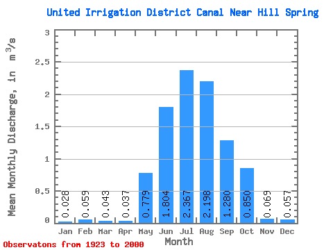
| Statistic | Jan | Feb | Mar | Apr | May | Jun | Jul | Aug | Sep | Oct | Nov | Dec | Annual |
|---|---|---|---|---|---|---|---|---|---|---|---|---|---|
| Mean | 0.03 | 0.06 | 0.04 | 0.04 | 0.78 | 1.80 | 2.37 | 2.20 | 1.28 | 0.85 | 0.07 | 0.06 | |
| Standard Deviation | 0.05 | 0.12 | 0.78 | 1.07 | 1.18 | 0.79 | 0.44 | 0.44 | 0.16 | ||||
| Min | 0.03 | 0.06 | 0.00 | 0.00 | 0.00 | 0.05 | 0.30 | 0.73 | 0.32 | 0.03 | 0.00 | 0.06 | |
| Max | 0.03 | 0.06 | 0.11 | 0.77 | 3.27 | 4.64 | 6.10 | 4.00 | 2.20 | 2.13 | 0.71 | 0.06 | |
| Coefficient of Variation | 1.07 | 3.31 | 1.00 | 0.59 | 0.50 | 0.36 | 0.34 | 0.52 | 2.30 |
 Return to R-Arctic Net Home Page