|
|
|||||||||||||||||
| Point ID: 9159 | Downloads | Plots | Site Data | Code: 15109000 |
|
|
|||||||||||||||||
| Download | |
|---|---|
| Site Descriptor Information | Site Time Series Data |
| Link to all available data | |
| View: | Time Series | All |
| Units: | mm |
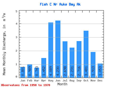
| Statistic | Jan | Feb | Mar | Apr | May | Jun | Jul | Aug | Sep | Oct | Nov | Dec | Annual |
|---|---|---|---|---|---|---|---|---|---|---|---|---|---|
| Mean | 0.80 | 0.99 | 0.74 | 1.45 | 4.09 | 4.23 | 2.70 | 2.23 | 2.72 | 3.48 | 1.91 | 1.05 | 2.22 |
| Standard Deviation | 0.58 | 0.92 | 0.42 | 0.53 | 0.81 | 1.21 | 0.83 | 1.02 | 1.07 | 1.14 | 1.01 | 0.76 | 0.25 |
| Min | 0.08 | 0.12 | 0.11 | 0.56 | 2.66 | 2.09 | 1.39 | 0.62 | 1.14 | 1.35 | 0.43 | 0.22 | 1.65 |
| Max | 1.87 | 3.13 | 1.66 | 2.87 | 5.75 | 6.61 | 4.73 | 4.57 | 4.98 | 6.50 | 3.96 | 2.83 | 2.57 |
| Coefficient of Variation | 0.73 | 0.93 | 0.57 | 0.36 | 0.20 | 0.29 | 0.31 | 0.46 | 0.39 | 0.33 | 0.53 | 0.72 | 0.11 |
 Return to R-Arctic Net Home Page