|
|
|||||||||||||||||
| Point ID: 9150 | Downloads | Plots | Site Data | Code: 15108000 |
|
|
|||||||||||||||||
| Download | |
|---|---|
| Site Descriptor Information | Site Time Series Data |
| Link to all available data | |
| View: | Time Series | All |
| Units: | mm |
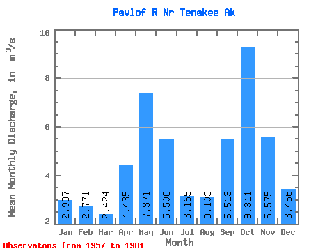
| Statistic | Jan | Feb | Mar | Apr | May | Jun | Jul | Aug | Sep | Oct | Nov | Dec | Annual |
|---|---|---|---|---|---|---|---|---|---|---|---|---|---|
| Mean | 2.99 | 2.77 | 2.42 | 4.43 | 7.37 | 5.51 | 3.17 | 3.10 | 5.51 | 9.31 | 5.58 | 3.46 | 4.65 |
| Standard Deviation | 2.51 | 1.96 | 1.10 | 1.55 | 2.22 | 1.87 | 0.86 | 1.65 | 2.39 | 4.17 | 2.44 | 2.16 | 0.54 |
| Min | 0.43 | 0.41 | 0.59 | 1.67 | 3.19 | 2.12 | 1.56 | 1.04 | 1.62 | 3.24 | 0.97 | 0.69 | 3.44 |
| Max | 11.10 | 7.77 | 5.28 | 7.46 | 13.36 | 10.03 | 4.63 | 7.15 | 10.56 | 22.02 | 12.01 | 7.46 | 5.52 |
| Coefficient of Variation | 0.84 | 0.71 | 0.46 | 0.35 | 0.30 | 0.34 | 0.27 | 0.53 | 0.43 | 0.45 | 0.44 | 0.62 | 0.12 |
 Return to R-Arctic Net Home Page