|
|
|||||||||||||||||
| Point ID: 9148 | Downloads | Plots | Site Data | Code: 15106960 |
|
|
|||||||||||||||||
| Download | |
|---|---|
| Site Descriptor Information | Site Time Series Data |
| Link to all available data | |
| View: | Time Series | All |
| Units: | mm |
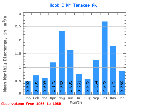
| Statistic | Jan | Feb | Mar | Apr | May | Jun | Jul | Aug | Sep | Oct | Nov | Dec | Annual |
|---|---|---|---|---|---|---|---|---|---|---|---|---|---|
| Mean | 0.50 | 0.71 | 0.61 | 1.18 | 2.33 | 1.64 | 0.75 | 0.57 | 1.26 | 2.67 | 1.78 | 0.85 | 1.25 |
| Standard Deviation | 0.30 | 0.64 | 0.36 | 0.50 | 0.64 | 0.74 | 0.31 | 0.28 | 0.59 | 1.47 | 0.98 | 0.54 | 0.20 |
| Min | 0.14 | 0.10 | 0.21 | 0.32 | 1.17 | 0.67 | 0.25 | 0.21 | 0.63 | 0.84 | 0.33 | 0.26 | 0.99 |
| Max | 1.13 | 2.28 | 1.39 | 2.13 | 3.49 | 2.97 | 1.33 | 1.12 | 2.75 | 6.03 | 3.40 | 1.77 | 1.63 |
| Coefficient of Variation | 0.60 | 0.90 | 0.59 | 0.42 | 0.27 | 0.45 | 0.42 | 0.49 | 0.47 | 0.55 | 0.55 | 0.64 | 0.16 |
 Return to R-Arctic Net Home Page