|
|
|||||||||||||||||
| Point ID: 9123 | Downloads | Plots | Site Data | Code: 05BM015 |
|
|
|||||||||||||||||
| Download | |
|---|---|
| Site Descriptor Information | Site Time Series Data |
| Link to all available data | |
| View: | Time Series | All |
| Units: | mm |
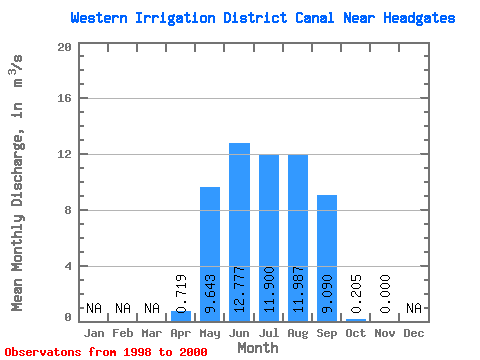
| Statistic | Jan | Feb | Mar | Apr | May | Jun | Jul | Aug | Sep | Oct | Nov | Dec | Annual |
|---|---|---|---|---|---|---|---|---|---|---|---|---|---|
| Mean | 0.72 | 9.64 | 12.78 | 11.90 | 11.99 | 9.09 | 0.20 | 0.00 | |||||
| Standard Deviation | 0.45 | 3.61 | 3.84 | 6.20 | 3.76 | 1.82 | 0.35 | 0.00 | |||||
| Min | 0.20 | 5.53 | 8.53 | 6.80 | 7.66 | 7.37 | 0.00 | 0.00 | |||||
| Max | 0.98 | 12.30 | 16.00 | 18.80 | 14.50 | 11.00 | 0.61 | 0.00 | |||||
| Coefficient of Variation | 0.63 | 0.38 | 0.30 | 0.52 | 0.31 | 0.20 | 1.73 |
 Return to R-Arctic Net Home Page