|
|
|||||||||||||||||
| Point ID: 91 | Downloads | Plots | Site Data | Code: 05AD012 |
|
|
|||||||||||||||||
| Download | |
|---|---|
| Site Descriptor Information | Site Time Series Data |
| Link to all available data | |
| View: | Time Series | All |
| Units: | mm |
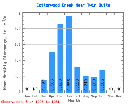
| Statistic | Jan | Feb | Mar | Apr | May | Jun | Jul | Aug | Sep | Oct | Nov | Dec | Annual |
|---|---|---|---|---|---|---|---|---|---|---|---|---|---|
| Mean | 0.16 | 0.51 | 0.86 | 0.95 | 0.32 | 0.21 | 0.20 | 0.28 | |||||
| Standard Deviation | 0.22 | 0.18 | 0.75 | 0.79 | 0.39 | 0.16 | 0.16 | 0.28 | |||||
| Min | 0.02 | 0.26 | 0.12 | 0.17 | 0.07 | 0.07 | 0.08 | 0.10 | |||||
| Max | 0.65 | 0.65 | 2.35 | 2.52 | 1.14 | 0.47 | 0.57 | 0.95 | |||||
| Coefficient of Variation | 1.37 | 0.35 | 0.87 | 0.83 | 1.22 | 0.74 | 0.80 | 0.98 |
 Return to R-Arctic Net Home Page