|
|
|||||||||||||||||
| Point ID: 9092 | Downloads | Plots | Site Data | Code: 15493400 |
|
|
|||||||||||||||||
| Download | |
|---|---|
| Site Descriptor Information | Site Time Series Data |
| Link to all available data | |
| View: | Time Series | All |
| Units: | mm |
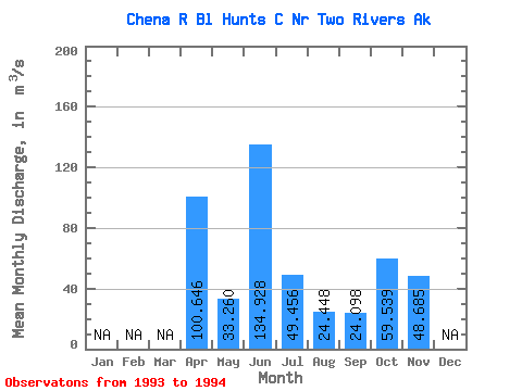
| Statistic | Jan | Feb | Mar | Apr | May | Jun | Jul | Aug | Sep | Oct | Nov | Dec | Annual |
|---|---|---|---|---|---|---|---|---|---|---|---|---|---|
| Mean | 100.65 | 33.26 | 134.93 | 49.46 | 24.45 | 24.10 | 59.54 | 48.69 | |||||
| Standard Deviation | |||||||||||||
| Min | 100.65 | 33.26 | 134.93 | 49.46 | 24.45 | 24.10 | 59.54 | 48.69 | |||||
| Max | 100.65 | 33.26 | 134.93 | 49.46 | 24.45 | 24.10 | 59.54 | 48.69 | |||||
| Coefficient of Variation |
 Return to R-Arctic Net Home Page