|
|
|||||||||||||||||
| Point ID: 9061 | Downloads | Plots | Site Data | Code: 49072 |
|
|
|||||||||||||||||
| Download | |
|---|---|
| Site Descriptor Information | Site Time Series Data |
| Link to all available data | |
| View: | Time Series | All |
| Units: | mm |
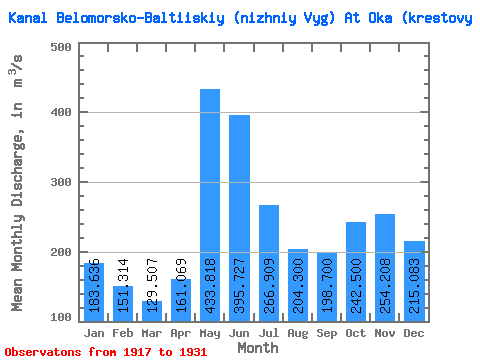
| Statistic | Jan | Feb | Mar | Apr | May | Jun | Jul | Aug | Sep | Oct | Nov | Dec | Annual |
|---|---|---|---|---|---|---|---|---|---|---|---|---|---|
| Mean | 183.64 | 151.31 | 129.51 | 161.07 | 433.82 | 395.73 | 266.91 | 204.30 | 198.70 | 242.50 | 254.21 | 215.08 | 232.53 |
| Standard Deviation | 65.08 | 51.66 | 38.83 | 74.68 | 63.76 | 104.51 | 65.68 | 46.48 | 77.08 | 83.22 | 103.55 | 72.55 | 36.50 |
| Min | 93.90 | 88.90 | 80.80 | 85.00 | 348.00 | 254.00 | 184.00 | 136.00 | 124.00 | 103.00 | 97.50 | 103.00 | 192.25 |
| Max | 306.00 | 269.00 | 225.00 | 347.00 | 573.00 | 587.00 | 368.00 | 296.00 | 389.00 | 345.00 | 486.00 | 368.00 | 317.50 |
| Coefficient of Variation | 0.35 | 0.34 | 0.30 | 0.46 | 0.15 | 0.26 | 0.25 | 0.23 | 0.39 | 0.34 | 0.41 | 0.34 | 0.16 |
 Return to R-Arctic Net Home Page