|
|
|||||||||||||||||
| Point ID: 9038 | Downloads | Plots | Site Data | Code: 71274 |
|
|
|||||||||||||||||
| Download | |
|---|---|
| Site Descriptor Information | Site Time Series Data |
| Link to all available data | |
| View: | Time Series | All |
| Units: | mm |
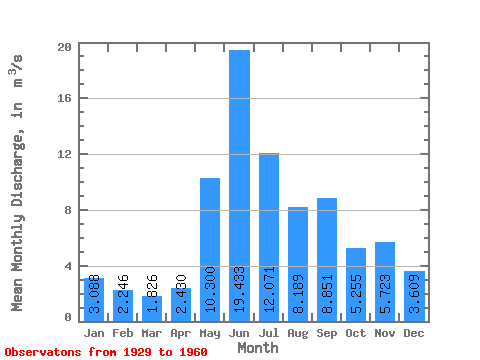
| Statistic | Jan | Feb | Mar | Apr | May | Jun | Jul | Aug | Sep | Oct | Nov | Dec | Annual |
|---|---|---|---|---|---|---|---|---|---|---|---|---|---|
| Mean | 3.09 | 2.25 | 1.83 | 2.43 | 10.30 | 19.43 | 12.07 | 8.19 | 8.85 | 5.25 | 5.72 | 3.61 | 7.36 |
| Standard Deviation | 0.81 | 0.43 | 0.41 | 1.49 | 5.19 | 8.01 | 5.18 | 4.45 | 7.48 | 2.70 | 2.49 | 1.18 | 1.36 |
| Min | 1.96 | 1.61 | 1.34 | 1.23 | 4.08 | 11.00 | 5.59 | 3.54 | 4.00 | 2.04 | 2.09 | 1.92 | 6.20 |
| Max | 3.84 | 2.74 | 2.39 | 4.96 | 18.40 | 33.40 | 20.60 | 16.40 | 25.20 | 10.00 | 9.21 | 5.13 | 9.30 |
| Coefficient of Variation | 0.26 | 0.19 | 0.23 | 0.61 | 0.50 | 0.41 | 0.43 | 0.54 | 0.84 | 0.52 | 0.43 | 0.33 | 0.18 |
 Return to R-Arctic Net Home Page