|
|
|||||||||||||||||
| Point ID: 9021 | Downloads | Plots | Site Data | Code: 71210 |
|
|
|||||||||||||||||
| Download | |
|---|---|
| Site Descriptor Information | Site Time Series Data |
| Link to all available data | |
| View: | Time Series | All |
| Units: | mm |
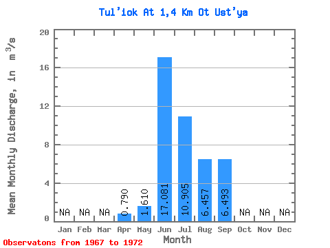
| Statistic | Jan | Feb | Mar | Apr | May | Jun | Jul | Aug | Sep | Oct | Nov | Dec | Annual |
|---|---|---|---|---|---|---|---|---|---|---|---|---|---|
| Mean | 0.79 | 1.61 | 17.08 | 10.90 | 6.46 | 6.49 | |||||||
| Standard Deviation | 4.04 | 3.64 | 1.32 | 2.86 | |||||||||
| Min | 0.79 | 1.61 | 12.20 | 7.02 | 4.95 | 4.37 | |||||||
| Max | 0.79 | 1.61 | 22.80 | 14.30 | 8.08 | 9.75 | |||||||
| Coefficient of Variation | 0.24 | 0.33 | 0.20 | 0.44 |
 Return to R-Arctic Net Home Page